
A Collaborative Study of the Bryophytes in Texas’ Southern Plains and prairies
Yes, there are bryophytes in south Texas. They may be a bit harder to find than in other regions of the state, but they are there. In fact, there are a few species in deep south Texas that reach the northern limits of distribution in the Rio Grande Valley.
Principal Investigators
Dale A. Kruse and Cynthia M. Galloway
The goal of the South Texas Bryophyte Project (STBP) is to collect and disseminate data on the presence, and current distribution, of bryophytes in the state’s southernmost region. Distributional data is from published literature references, online data sources, and regional collections made by the PI’s, their students, and volunteers throughout the state.
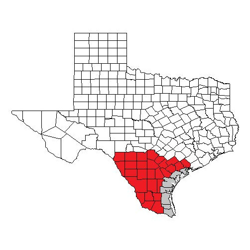
South Texas Plains and Prairies Region
The geographic extent of the study area is generally from the Rio Grande River north to San Antonio, then east to the Gulf of Mexico. The region as defined here consists of 36 counties which comprise all of the South Texas Plains and the lower half of the Gulf Prairies and Marshes Ecoregions (Hatch, et al., 1990). Counties included in the study area are: Aransas, Atascosa, Bee, Bexar, Brooks, Calhoun, Cameron, DeWitt, Dimmit, Duval, Frio, Goliad, Hidalgo, Jackson, Jim Hogg, Jim Wells, Karnes, Kenedy, Kinney, Kleberg, La Salle, Live Oak, Maverick, McMullen, Medina, Nueces, Refugio, San Patricio, Starr, Uvalde, Victoria, Webb, Willacy, Wilson, Zapata, Zavala.
Ecoregion descriptions
Gulf Prairies and Marshes
The Gulf Prairies Marshes (GPM), covering approximately 500,000 acres, are on a narrow strip of lowlands adjacent to the coast and the barrier islands (e.g., Padre Island), which extend from Mexico to Louisiana. The GPM include the nearly flat plain extending 30 to 80 miles inland from the Gulf Marshes. The Gulf Marshes are a low, wet, marshy coastal area, commonly covered with saline water, and range from sea level to a few feet in elevation. The Gulf Prairies are nearly level and virtually undissected plains having slow surface drainage and elevations from sea level to 250 feet. The original vegetation types of the Gulf Prairie were tallgrass prairie and post oak savannah. However, trees and shrubs such as honey mesquite (Prosopis glandulosa), oaks (Quercus), and acacia (Acacia) have increased and thicketized in many places. Characteristic oak species are live oak (Quercus virginiana) and post oak (Q. stellata). Typical acacias are huisache (Acacia smallii) and blackbrush (A. rigidula). Bushy sea-ox-eye (Borrichia frutescens), a dwarf shrub, is also typical.
South Texas Plains
The South Texas Plains lie south of a line from San Antonio to Del Rio. This area is the western extension of the Gulf Coastal Plains merging with the Mexico Plains on the west. The area is a nearly level to rolling, slightly to moderately dissected plain. The original vegetation was an open grassland or savannah-type along the coastal areas and brushy chaparral-grassland in the uplands (Johnston 1963). Originally, oaks and mesquite and other brushy species formed dense thickets only on the ridges, and oak, pecan, and ash were common along streams (Inglis 1964). Continued grazing and cessation of fires altered the vegetation to such a degree that the region is now commonly called the Texas Brush Country. Many woody species have increased, including mesquite, live oak, acacia, brazil (Zizyphus obovata), spiny hackberry (Celtis pallida), whitebrush (Aloysia gratissima), lime pricklyash (Zanthoxylum fagara), Texas persimmon (Diospyros texana), shrubby blue sage (Salvia ballotiflora), and lotebush (Zizyphus obtusifolia).